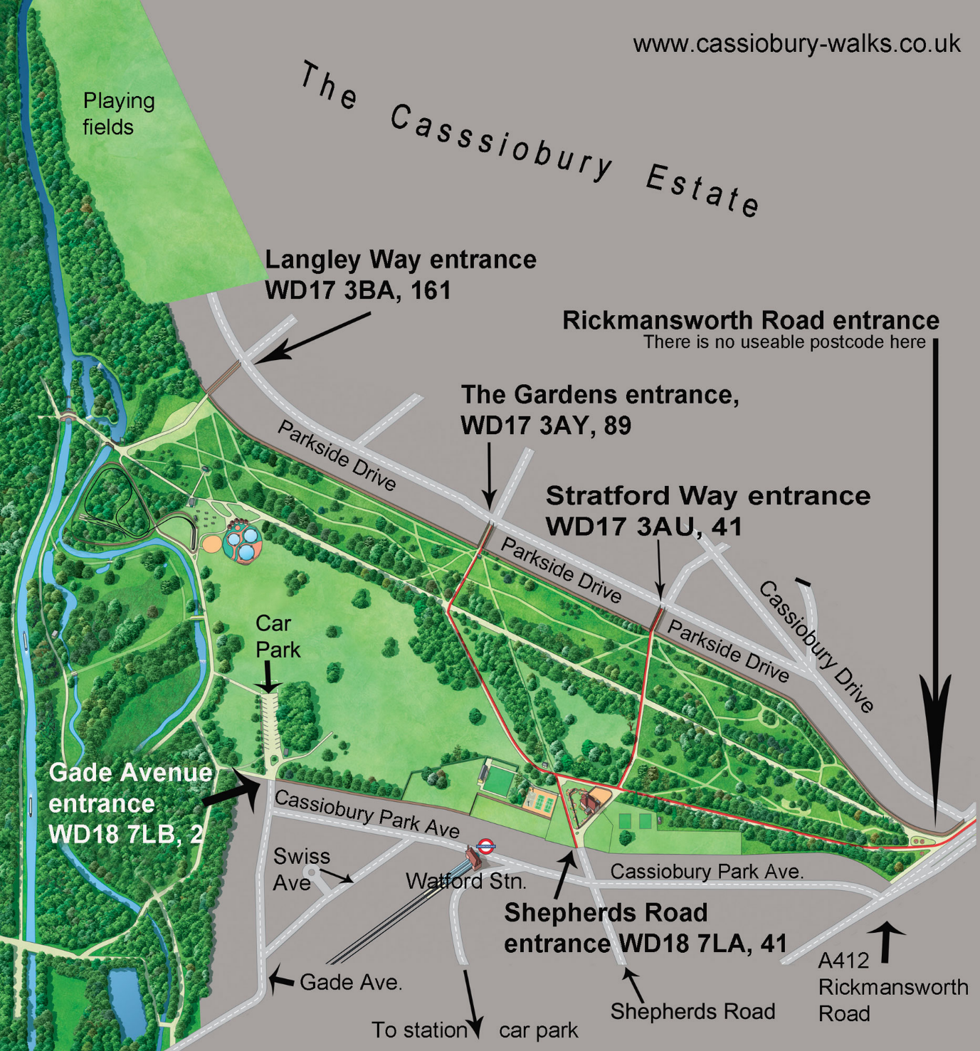
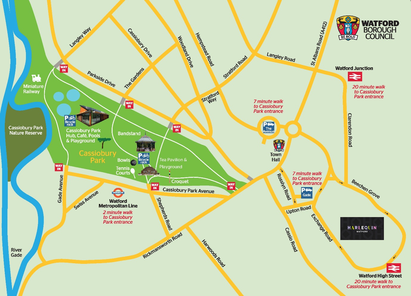
Scroll to the bottom for maps.
DIRECTIONS TO THE PARK FROM THE NEAREST CAR PARKS
CASSIOBURY CAR PARK, WD18 7LG
* * This is the car park in the park, not to be confused with the Gade multi-storey car park in the town centre **
You don’t need directions to the park, this car park is in the park.
Note, for the fireworks this car park is for Blue Badge holders only, first-come first-served, no guarantee that you will get in.
CAR PARK DETAILS (2026)
Location, at the end (dead end) of Gade Avenue, Watford, WD18 7LG.
Opening Hours: 07:30 to 22:00hrs
Height Restriction: 2.1 metres.
Capacity: 217 spaces (with 12 disabled bays and 4 EV Charging Points).
Up to 2hrs free; 3hs £3.10; 4hrs £4.40; 5hrs £5.50; 6 hrs £6.60; maximum stay 6hrs. Payment by cash, Debit/Credit Card, RingGo (location code 5312750)
TO THE PARK FROM THE TOWN HALL CAR PARK AT WD17 3EX (Rickmansworth Road entrance, 4mns)
The postcode for the Town Hall itself (which you will see on the internet) is WD17 3DA but there is no parking at this postcode location. The car park entrance is at WD17 3EX in Peace Prospect on the Hempstead Road. If you are using sat-nave, approach it very slowly or you’ll miss it.
- This is the closest car park to the park (apart for the car park in the park) but:
it is small, only 38 spaces for public parking - it’s only open to the public evenings and weekends
- a sign says “First 30mns free” but the ticket machine doesn’t give a ‘free’ 30mn ticket
- it can be confused with the adjoining car parks which are for the college and NHS clinic only
- it can be confused with the Town Hall Roundabout car park (Avenue Car Park) on the other side of the road.
CAR PARK DETAILS (2026)
Open to the public Mon-Fri 5pm to midnight (incl. bank holidays), weekends 7am-midnight. There’s a barrier so assume (we don’t know!) the car park is physically closed outside of these hours.
38 general bays, 6 disabled bays, and 4 electric-car bays with 2 chargers.
£1.20 up to 1hr, £2.30 up to 2hrs, £3.40 up to 3hrs, £4.50 up to 4hrs, £6.70 all day. Motorcycles free with a ticket. Payment by coins, card or RingGo (Location Code 26789).
DIRECTIONS TO THE RICKMANSWORTH ROAD ENTRANCE (4mns)
1) Exit in the corner between bay 1 and bay 112, pedestrian signs point to Watford Colosseum
2) Take the passageway by the side of Colosseum and turn right into the main road
3) The entrance to the park will be on your right.
You are now there. But where ‘there’ is – that depends on where you are going, it’s a 20mn walk to the far side of the park, see IN THE PARK / FROM THE RICKMANSWORTH ROAD ENTRANCE.
TO THE PARK FROM AVENUE CAR PARK AT WD17 4NR (Rickmansworth Road entrance, 8mns)
Location, the top left (N.W.) of the ring road / bottom (south) of Hempstead Road, opposite Watford Leisure Centre and the Town Hall. This is known, locally, as The Town Hall Roundabout car park (because the car park is in the middle of the roundabout) – but its official name is Avenue Car Park. As you drive round the roundabout / mini 1-way system, hug the right lane. Note: this is not the Town Hall Car Park which is a few yards away on the other side of the road.
CAR PARK DETAILS (2026):
Open 24 hours (no barrier). Pay at machine Monday-Sunday 7am-midnight. 1hr £1.10, 2hrs £2.20, 3hrs £3.30, 4hr £3.40, all day £6.00. Payment by card, coins or RingGo (location 26788).
217 spaces including 12 disabled bays; 4 Charging points. Height Restriction 2.1 metres.
DIRECTIONS TO THE RICKMANSWORTH ROAD ENTRANCE (8mns)
Aim for the corner of the car park marked EXIT or SUBWAY
0mns. Take the subway.
At the end of the tunnel turn right up the steps (or take the slope) then continue ahead, towards the trees.
2½mns. Turn left at The Horns but keep left alongside the library (because the main path is closed while the Town Hall District is being developed, 2026).
Keep ahead but pass to the left of the underpass (i.e. do not go under the underpass!), follow the sign Colosseum Accessible Route.
4mns. The path loops round to the right, then just keep ahead (main road to your left).
5mns. You will pass Watford Colosseum. Then look into the distance, you will see a tall pole / transmitting mast.
8mns. The entrance to the park is by the mast, this is the Rickmansworth Road entrance. You are now there. But where ‘there’ is – that depends on where you are going, it’s a 20mn walk to the far side of the park, see IN THE PARK / FROM THE RICKMANSWORTH ROAD ENTRANCE.
TO THE PARK FROM WATFORD TOWN CENTRE GADE CAR PARK AT WD18 0JY (to Rickmansworth Road entrance 6 to 11mns)
* * This is the multi-story car park in the town centre, not to be confused with Cassiobury Car Park in the park **
If you are approaching the car park by foot from the pedestrianised High Street, aim for WD18 OJX. But if you are in a car you need to know that the entrance to the car park is in Rosslyn Road at WD18 OJY
BEWARE! There are many car parks, this is the Gade multi-storey car park (“CitiPark Gade Watford”) not to be confused with the car park in the park itself, which is 1½ miles away at the end of Gade Avenue.
ROUTE 1, 6mns, 8mns or 11mns
This is the faster route by about a minute but you have to cross two main roads (no crossings) which can add two minutes. Not a pleasant walk but worth a gamble if you are in a hurry.
Exit the car park from where you drove in and turn right into the road (Rosslyn Road, the road with houses and flats).
At the end turn left into the main road (Rickmansworth Road). The park will be on the right - but on the other side of road.
Option 1: some people run across the dual carriageway, survivors get to the park in 6mns
Option 2: turn sharp left down the steps (after you’ve crossed both halves of the first main road, easy to miss), round the slope then take the underpass, 8mns
Option 3, overshoot the park, cross at the pedestrian lights and walk back, 11mns.
ROUTE 2, 10mns
Nicer route, mostly pedestrianised, no roads to cross.
Exit by the lifts. If you find yourself at the other exit (where you came in, flats and houses in the street outside) go back through the car park (down the slope) to the other exit.
Turn left out the car park into the passage / service road.
0mns. Continue towards LEEDS BUILDING SOCIETY (2026), 50 paces.
Turn left into the pedestrianised high street. Keep ahead (ponds and fountains to your right). Those with small children may need to stop while they (the children) peer into the ponds or chase the pigeons.
4mns. Take the underpass (keep left, keep out of the cycle lane)
5mns. Just as you find yourself going up the other side, turn sharp left up the steps.
At the top of the steps turn left for just 10 paces, then right (the main road on the other side of the railings is Rickmansworth Road).
(To avoid the steps: from the underpass follow the ACCESSIBLE ROUTE signs: continue up the slope, do a u-turn at the top, follow the path, continue alongside Rickmansworth Road).
6mns. As you pass Watford Colosseum, look into the distance, you will see a tall pole / transmitting mast. The entrance to the park is by the mast.
10mns. you are now there. But where ‘there’ is – that depends on where you are going, it’s a 20mn walk to the far side of the park, see AROUND THE PARK FROM THE RICKMANSWORTH ROAD ENTRANCE to see where to go next.
DIRECTIONS TO THE PARK FROM WATFORD’S TWO RAILWAY STATIONS
TO THE PARK FROM WATFORD UNDERGROUND STATION (Shepherds Road entrance 4 minutes; Gade Avenue entrance 5 minutes)
TO THE SHEPHERDS ROAD ENTRANCE 4MNS TO THE GATE INTO THE PARK
Turn right onto the pavement then continue along the road (Cassiobury Park Avenue)
Cross at the lights
Turn left into Shepherds Road
Ahead into the park.
TO THE GADE AVENUE ENTRANCE 5MNS
Turn left out of the station and left into the road (Cassiobury Park Avenue)
Turn right into Gade Avenue, the road runs out at the entrance to the car park (in the park).
TO THE PARK FROM WATFORD JUNCTION STATION (Rickmansworth Road entrance 15mns)
There are a few routes from the station, this is the quickest, along the main road and under two underpasses. You might not like this route late at night.
0mns. From the pedestrian crossing outside the station. Cross the crossing and turn right along the pavement.
2mns. Turn left at the lights
5mns. Just before St John’s Road take the underpass: down the slope, turn left at the end, up the slope. Continue ahead, follow the pavement round to the right.
7½mns. Take the underpass: down the slope, turn left at the end, up the slope, continue ahead.
Turn left at The Horns but keep left alongside the library (because the main path is closed while the Town Hall District is being developed, 2026).
10½mns. Continue ahead onto the path Colosseum Accessible Route (do not take the underpass!). The path curves right and joins the pavement by the main road (Rickmansworth Road) – continue ahead.
You will pass Watford Colosseum. Then look into the distance, you will see a tall pole / transmitting mast.
15mns. The entrance to the park is by the mast, this is the Rickmansworth Road entrance. You are now there. But where ‘there’ is – that depends on where you are going, it’s a 20mn walk to the far side of the park, scroll down to AROUND THE PARK FROM THE RICKMANSWORTH ROAD ENTRANCE.
AROUND THE PARK (+ INFO & ATTRACTIONS)
IN THE PARK: FROM THE RICKMANSWORTH ROAD ENTRANCE
There are two paths, you can take the right fork or the left fork. Note, for the Cassiobury fireworks either fork will do, the left fork is slightly quicker, either way just follow the crowds.
If you take the right fork
(The numbers are total minutes from forking right)
Stratford Way exit on right, bandstand on left (free music Sundays July to Sept), also the finish-point for Parkrun (all 7½). The Gardens exit to your right (12). The Hub (Cedar Café and entrance to paddling pools) (both 16). The paddling pools are free but you need to book a timeslot. Picnic tables, ice cream van in summer, playground, and a path that forks right towards the Langley Road exit (all 17½).
Junction of paths (20½)
- at the junction of paths:
The numbers in brackets are distances, in minutes (if you don’t stop!).
Continue ahead past the picnic benches and across the bridge (the Rustic Bridge over the River Gade) (¼mn). This is the best bridge for Pooh Sticks, the best paddling is to the left, best fishing to the right (take a net); weir on right (worth a detour, see if you spot the remains of the mill).
Keep ahead over a second bridge (Ironbridge, over the Grand Union Canal) (1½mns), watch the boats negotiate the lock. Detour: the canal towpath to the left goes to London and the River Thames (about 9 miles), take the path to the right for the floating market (selected weekends in the Spring and Summer), keep going for Birmingham, Bristol, Liverpool or Hull.
I suggest you leave the towpath for another time. Instead, continue ahead (over the canal) towards the steps at the steep path for just 20 paces then turn right. Follow the path (Lime Walk) to the top of the hill to the junction of 5 paths (The Rotund) (18mns). Turn round, admire the view, return to the park. Or explore the wood (take care, it’s easy to get lost).
or (from the picnic benches) turn right for the Langley Way exit (exit onto Parkside 3mns).
or (from the picnic benches) fork left alongside the wooden fence, level crossing (wave to the trains) (1½ ), grownup playground (River Gade to your right) and the station for the miniature railway (both 2½), playground and bouncy castle (3).
If, from the Rickmansworth Road entrance, you take the left fork:
The numbers in brackets are distances, in minutes from when you fork left.
Grownup’s playground (4); Cassiobury Croquet club (5); Café Park, was called Café Cha Cha, includes playground for small children (6); drinking fountain, tennis courts, Shepherds Road exit on the left (all 7); path curves right, Watford Bowls Club (8). For the start-point for Parkrun keep ahead onto the fields (8½); for the fireworks just follow the crowds from here (10). Or follow the path as it curves to the right, to the next junction - ahead is The Gardens exit or turn left to pick up the route (at “The Gardens exit!) from the right fork (3½mns).